Satellite data and AI: revolutionizing forest monitoring and mitigating drought risk
In the third edition of the FORGENIUS Public Webinars we addressed how forests are facing increased mortality due to droughts triggered by climate change. Trees can die from either reduced photosynthesis during drought (carbon starvation) or air bubbles forming in their vascular system (hydraulic failure). Moreover, insect attacks, and other disturbances have caused a significant decline in the European forest carbon sink.
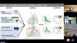
Project’s speaker, Dr. Nicolas Martin, presented a new model, SurEau, that considers various factors like climate data, plant characteristics, and soil properties to assess drought-induced tree mortality risk. It even tackles the challenge of estimating hidden soil water capacity through a self-calibration approach. While the model shows promise with initial tests, it's still sensitive to data quality, particularly for leaf area index. Researchers are planning to use SurEau in specific forest areas and improve leaf area data using LiDAR technology. This research offers a valuable tool for understanding and potentially mitigating drought's devastating effects on forests.
Our guest speaker, Dr. Philippe Ciais made it clear that forests are crucial for carbon sequestration and mitigating climate change and discussed how satellite data and artificial intelligence models can be used to improve forest monitoring.
Satellite data offers a way to monitor forest health at scale and high-resolution satellite imagery allows for detailed analysis. Furthermore, different sensors provide various data, including optical, radar, and microwave. Combining the data from these, plus ground observations and using deep learning models allows for creating detailed maps of forest characteristics like height, biomass, and biomass change.
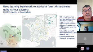
Dr. Ciais presented examples of using GEDI sensors data and Sentinel imagery to create a high-resolution map of forest height in France. A model is then built to estimate future carbon sink based on the disturbance severity trends and the growth curves derived from satellite data. The model's accuracy is validated by comparing its predictions with ground observations, showing promising results.
Another method uses satellite data to directly measure forest height changes. They address challenges related to phenology (seasonal variations) and develop a model that is resistant to these effects. Very high-resolution satellite imagery is used to identify individual trees and improve forest management.
Dr. Ciais, concludes that satellite data offers valuable tools for forest monitoring at various scales, such as year-on-year monitoring of height changes, revealing growth rates for different tree species and regions.
Follow the project on social media at @FORGENIUS_EU and subscribe to the newsletter!
Watch the webinar recording!