A new downscaling method for global radiation in complex terrain enhances environmental models
Key messages
- Enhancing the relevance of remote sensing data is key for application in sites with complex topography.
- Our method is primarily process-based, accounting for direct mountain shading and reduced luminosity in deep valleys.
- We demonstrate a significant improvement in radiation data accuracy over rugged terrain, positively impacting results derived from these data, including in modelling applications.
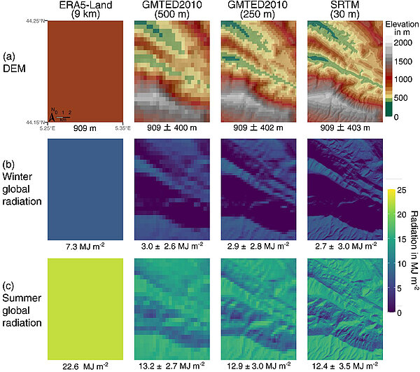
Accurate global radiation data are essential for forest process-based models, as they influence key functions like photosynthesis and transpiration. However, in mountainous regions, coarse-resolution radiation data (approximately 9 km from remote sensing) often fails to capture the variability caused by terrain features such as mountain shadows and deep valleys. To tackle this challenge, we have developed a downscaling model that refines large-scale radiation data to match the detailed resolution of topography. This innovative method separates radiation into direct and diffuse components, accounting for the shading effects of surrounding mountains and the reduced light in deep valleys. When applied to the Mont Ventoux area in southeastern France, our approach significantly improved the accuracy of radiation data, especially at resolutions finer than 150 meters. Incorporating this high-resolution radiation data into models, such as CASTANEA for tree growth and SurEau for plant hydraulics, has demonstrated remarkable improvements in predicting forest functions and assessing climate-related risks. This advancement can provide to forest managers more precise information for effective decision-making in complex terrains.