Lessons from monitoring evapotranspiration
Much can be learned about ecosystem functioning, biophysical processes, and drought-related changes in the soil–plant–atmosphere system by studying evapotranspiration (ET). ET is the combined process of water evaporating from soil and transpiring from plants, and monitoring it reveals how vegetation responds to climate variations across space and time.
Using satellite remote sensing, modelling and reanalysis products, together with in situ observations, a new study evaluated freely available ET datasets. Conducted at eight Integrated Carbon Observation System (ICOS) sites across central Europe between 2017 and 2020, it assessed how well these products capture seasonal and yearly changes in water use by vegetation.
The results show that, despite differences in resolution and methods, most ET products displayed similar seasonal patterns and relatively low uncertainties. Performance, however, varied by land cover: agricultural sites showed the largest deviations due to complex and changing crops, while evergreen needle-leaf forests provided the most consistent results thanks to their stable vegetation.
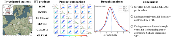
The study also highlighted sharp contrasts between years. In 2017, a relatively wet year, ET was mainly driven by atmospheric demand – plants transpired freely because soil moisture was sufficient. In 2018, a severe drought year, ET dropped sharply as soil moisture declined and the air became drier, limiting plant water use.
Understanding ET is vital for tracking how ecosystems use water and how they respond to climate extremes. Reliable ET products are crucial for monitoring droughts, managing agriculture, and predicting future water availability. While current products perform well, improving spatial resolution and combining different data sources could make drought monitoring even more precise.