Unlocking forest potential: innovations in genetic conservation and environmental monitoring
The fifth FORGENIUS Public Webinar, held on 12 December 2024, showcased cutting-edge advancements in genetic conservation and environmental monitoring. Highlights included Dr. Marjana Westergren’s insights into EUFGIS indices to characterise Genetic Conservation Units (GCU) and Mr. Giulio Marchi’s presentation on Earth Map, an innovative geospatial tool.
Characterizing GCUs through indices
Dr. Westergren began by outlining the process of selecting indices to describe GCUs. These indices are pivotal for monitoring forest genetic resources, particularly their diversity, distinctiveness, and vulnerability. The selection was informed by feedback from end users, who prioritized:
- Diversity: Understanding genetic variation within GCUs.
- Distinctiveness: Differentiating GCUs based on unique genetic traits.
- Vulnerability: Assessing susceptibility to environmental stressors and adaptive capacity.
Dr. Westergren emphasized that the indices are not rigidly defined but adaptable to evolving research and user needs.
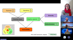
Drawing from the IPCC 2007 framework, vulnerability was analysed as the intersection of three key components. The first, exposure, refers to external environmental stresses such as rising temperatures and other climatic changes. The second component, sensitivity, encompasses the internal characteristics of populations that influence their ability to respond to these stresses. Lastly, adaptive capacity represents the genetic potential of populations to cope with changes, which is closely tied to their diversity and distinctiveness. Together, these elements provide a comprehensive understanding of vulnerability in the context of genetic conservation.
For example, populations with high genetic diversity typically exhibit greater adaptive capacity and lower vulnerability.
Data for developing these indices came from diverse sources, including remote sensing, genomic studies, and phenotypic observations. Dr. Westergren categorized the indices into five groups:
- Environmental indices: Focus on exposure factors such as orography, soil properties, and vegetation indexes.
- Forest indices: Practical metrics like tree biomass, basal area, and natural regeneration, which are easily understood by forest managers.
- Genetic indices: Measures such as genetic diversity, genetic differentiation, genomic offset, inbreeding coefficients, and reproductive traits to assess genetic diversity and distinctiveness.
- Modelled indices: Simulated metrics including drought vulnerability and risk of frost damage, which offer predictive insights.
- Phenotypic indices: Field-measured traits like hydraulic properties and wood density, signalling tree health and adaptability.
Highlights of specific indices
- Genomic offset: Quantifies the genetic shift required for populations to maintain fitness under changing climates. Higher offsets were observed in marginal populations in maritime pine, signalling greater vulnerability.
- Abundance of natural regeneration: Signals potential management issues if regeneration is lacking, prompting interventions like canopy thinning or seed collection for assisted or artificial regeneration.
- Risk of frost damage: Simulates the percentage of leaf damage due to frost, revealing stress levels and potential vulnerabilities.
The indices will be integrated into the European Information System on Forest Genetic Resources (EUFGIS), the only transnational information system on forest genetic resources (FGR) in Europe. The platform is set to launch publicly in October next year. Users will have access to a wealth of data, including linked information systems like CHELSA and the European Drought Observatory. Indices will feature intuitive visualizations and detailed descriptions to facilitate understanding and application.
EarthMap for climate and environmental monitoring
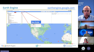
Mr. Marchi introduced EarthMap, a user-friendly tool developed by FAO to simplify access to environmental and climate data. By leveraging Google Earth Engine’s powerful computing platform, EarthMap provides an intuitive interface that eliminates the need for coding, making geospatial analysis accessible to a broader audience.
This platform stands out for its point-and-click usability, allowing users to import polygons or draw areas of interest to analyse data seamlessly. The platform hosts an extensive range of datasets covering environmental and climatic parameters, such as vegetation indices, temperature trends, and soil properties. These resources enable users to perform detailed statistical analyses, generating temporal statistics for selected regions to identify trends like heat stress or drought vulnerability over time. Its open approach ensures transparency by linking directly to original data sources and supporting exports in user-friendly formats like CSV and XLS.
EarthMap serves as a powerful tool for various applications. It has been instrumental in supporting policy design for major initiatives undertaken by organizations such as the World Bank and the Green Climate Fund. Its capabilities extend to climate risk analysis through customizations like the Strata portal, which examines the convergence of environmental and socioeconomic risks to provide insights into climate security. Moreover, EarthMap plays a crucial role in training and capacity building, equipping users worldwide with skills in geospatial analysis and project design.
This tool continues to evolve with customizations for specific needs, such as forest monitoring via the WHISP portal and climate security analytics with the Strata portal. The platform’s open design and continuous updates make it a valuable resource for addressing global environmental challenges.
Dr. Marjana Westergren’s and Mr. Giulio Marchi’s presentations underscored the sophisticated methodologies and interdisciplinary approaches driving the FORGENIUS project. These innovations are paving the way for enhanced genetic conservation and climate monitoring tools. As project coordinator Ivan Scotti remarked, “This is really showing that the FORGENIUS project is getting closer to its final goals.” The webinar not only highlighted the advancements achieved but also demonstrated the project’s growing relevance in addressing critical environmental challenges and its commitment to sustainable forest management.
Follow the project on social media at @FORGENIUS_EU and subscribe to the newsletter!
Watch the webinar recording!